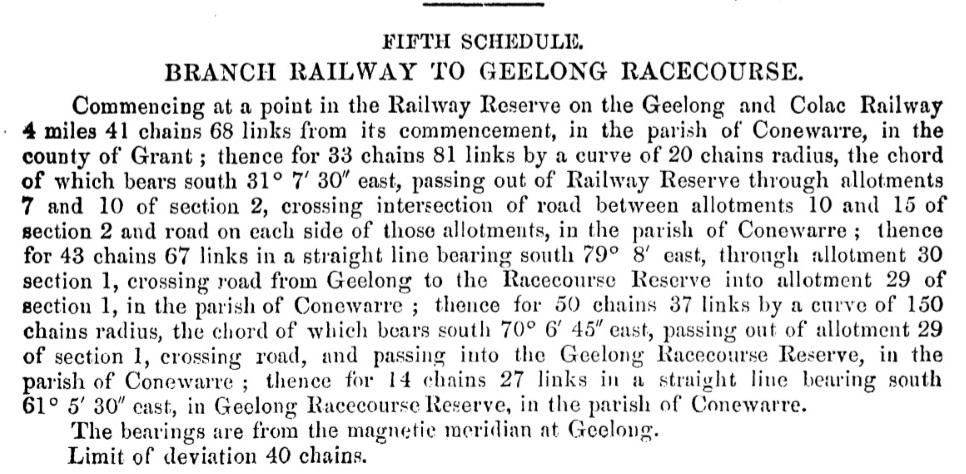
On Saturday 14 December 1918 the Geelong Advertiser published a list completed for the Railway Commissioners and the Historical Society of Victoria. Backblock towns are not on this list.
Bacchus Marsh — named after Captain WH Bacchus, who settled in the Melbourne end of the valley early in 1838
Ballan — received its title from a pastoral station close by owned by Robert von Steiglitz, and named after an estate in Ireland
Bannockburn — copied from Stirlingshire, Scotland where Robert Bruce defeated Edward II
Banool — is an abbreviation of "Moorbanool." Bannool means "hill."
Barwon — is a native word, meaning "magpie," and was applied to the river by JH Wedge in 1835 and written "Barwourne" meaning "Great wide."
Beeac — native "Saltwater," a chief of the local tribe of aborigines
Beech Forest — after a forest in the locality containing numbers of so-called beech trees (really myrtle).
Berringa — native name for the rainbow bird, "Bee eater."
Berrybank — after Mack's "Berrybank" station, near Cressy. Acquired in the early fifties by the late JG Mack, and named by him after the home of his family in Berwickshire, Scotland. The railway station is in or about the centre of the original estate.
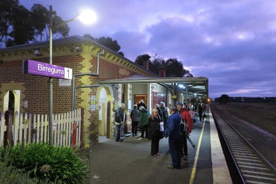
Birregurra — is the native name for the springs on the Birregurra Creek, near Bleak House station; "Burrai Gurray," a kangaroo camp.
Buckley — from Buckley's Falls, after William Buckley, the "wild white man."
Colac — native "Kolak," sand. There is a high bank of sand along the Colac Lake.
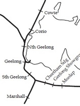
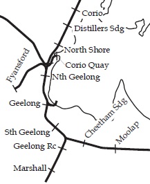
Corio — takes its name from Corio Bay. In the native language Corio means a small marsupial.
Cressy — is out of compliment to Jean Duverney and his wife "Rosine," after Cressy in France. The place was once known as the "Frenchman's"; the inn opened by the Duverneys is still so called.
Crowes — after Mr Con Crowe, a local land owner.
Curlewis — is after an early squatter, who settled in the locality in 1838.
Dean's Marsh — after the owner of the pastoral station. The railway authorities altered the name from Dean's Marsh to its present form.
Derrinallum — native "Dherinallum,"white sea bird, tern, or sea swallow. Flocks of these birds frequent the salt marshes in the neighbourhood. "Tirrinchillum,"or "Tarrinallum," a hill of fire.
Drysdale — after Miss Drysdale who with her partner Miss Newcomb, settled in that locality in 1840.
Duverney — followed an early French settler named Jean Duverney, who came to Australia with Messrs McArthur and Nicolas Cole about 1837.
Elaine — by a reader of Tennyson, after "Elaine the fair, Elaine the loveable, Elaine the lily maid of Astolat."
Forrest — after Charles Lamond Forrest MLA for Polwarth for many years.
Geelong — was given its title by Governor Bourke in 1837 from the native name of the hill upon which the town was built. "Geelong" means the place of the cliff. Sutherland gives the meaning as "White sea bird of curlew" and Mitchell as "swampy plains, resort of native companions."
Gerangamete — is after a run or pastoral station in the locality.
Gellibrand — from the Gellibrand River, so called after Joseph Tice Gellibrand, a member of Batman's Association engaged in the settlement of Port Phillip in 1835. He was lost in the bush with a companion named Hesse and probably killed by blacks.
Gheringhap — native, the yellow blossom of the black wattle, a species of white gum, the haunt or habitat of the opossum.
Grovedale — the name given to his house by one of the early English residents, and selected by the Shire Council as the name of the station when it was deemed advisable to change it from Germantown soon after the outbreak of the war.
Inverleigh — signifies "mouth of the River Leigh" and describes its situation.
Irrewarra — native "Nawailah," the name of Calvert's home station nearby. The railway station was formerly called "Ondit Road."
Lara — was originally known as "Duck Ponds." It was here that Hume and Hovell terminated their journey in 1824, and rested a few days before returning. The stream appeared on an early map as "Hovell's" Creek, but some of the early settlers called it "Duck Ponds." in the middle seventies the name was changed to "Hovell's Creek," but public protest caused it to be re-christened Lara, which in the language of the natives, means "hut on stony ground." The word is akin to "Lah," which means stone.
Lavers Hill — after Mr Laver, the first settler in the neighbourhood from Gippsland.
Leopold — in honor of Prince Leopold, a son of Queen Victoria.
Lethbridge — first known as the "Muddy Waterholes." It was a camping place for travellers on their way to the goldfields. On the completion of the Ballarat railway line the place was called Lethbridge, after one of the leading officials engaged in the construction.
Little River — The name was applied to, rather than bestowed upon, the stream by way of contrasting it with the larger rivers, such as the Werribee, seen by the pioneers in 1835-6. No other name has been applied to the stream, and the station was appropriately named after it though the name Bulban was given to the township a few years ago.
Lismore — was known in the early days as Brown's Waterholes. Situated on the Gala estate originally owned by John Brown, from Galashiels, Scotland. In the fifties it was named Lismore probably by Mr Skene, Surveyor-General after Lismore, in county Waterford, Ireland.
Marcus — after Marcus Hill, a remarkable local feature.
Maroona — took its name from an old pastoral station or run in that locality.
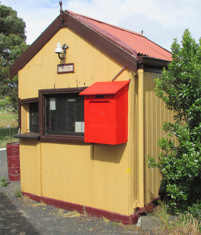
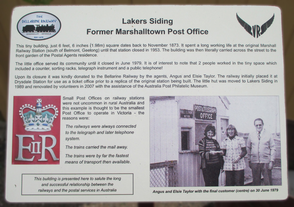
Marshall — was known as the Breakwater until the men engaged in the tanning industry in that locality established a settlement, which was called Marshall's Town, after Mr Foster Marshall, a prominent resident. The Railway authorities abbreviated the name to Marshall.
Mannerim — after the Mannerim estate, Drysdale.
Meredith — is named after Mr Charles Meredith, of Tasmania.
Moolap — native means a gathering place of the blacks when about to procure saltwater shell fish. Moolap was one of the early landing places of the pioneers.
Moorabool — the curlew, according to Geelong natives. A corruption of Marrarbool. "Moorroobull" ghost.
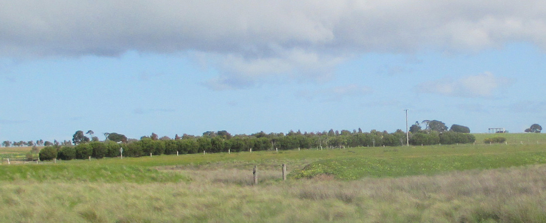
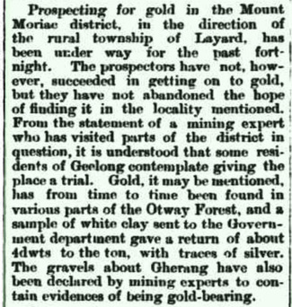
Moriac — formerly Mt Moriac, native, "Morack Hill."
Murroon — is a native name, "The forehead."
North Shore — is descriptive of the position of the station in relation to Corio Bay.
Ondit — after Lake Ondit, which is near the station.
Pennyroyal — is after Pennyroyal Creek near by, where the plant known by that name grew plentifully.
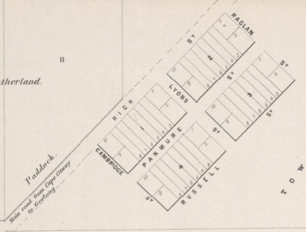
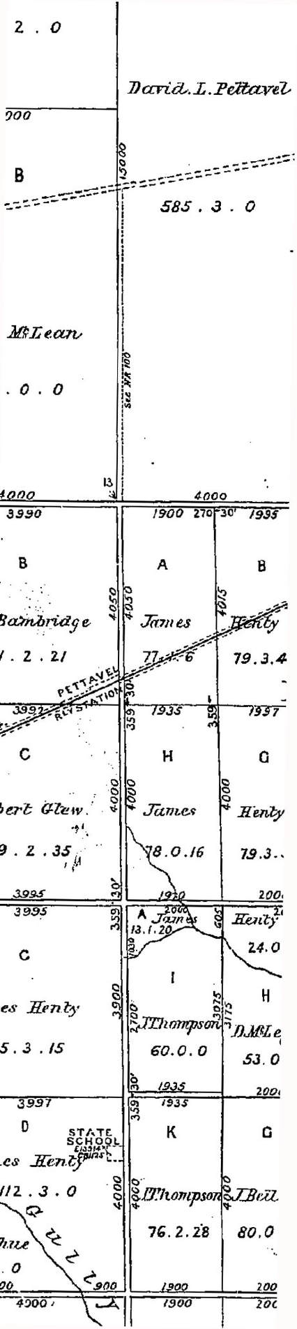
Pettavel — formerly Pettavel Road, is named after a Swiss vigneron, who came from Neuchâtel about the middle forties, and settled in the Barrabool Hills.
Pura Pura — is the aboriginal name for the "blow hole," as it is now known. This unique and curious volcanic freak, which is situated on the south-east slope of Mount Hamilton consists of a square opening in the rocky ground, about 15 feet deep, with absolutely unscaleable walls, and with a solid natural bridge spanning it from side to side (about 12 feet across). The cavity is always about half full of clear spring water of the best quality, which was, no doubt, the principal attraction to the blacks for camping operations.
Queenscliff — is named in honor of Queen Victoria. Was formerly called Shortland's Bluff, after Mr Shortland, of HMS Rattlesnake, who with other officers of the ship, was engaged in the survey of Port Phillip Bay.
Rokewood — is said to have been named by English miners after the Rokewood family of Coldham Hall, Suffolk, England.
Weeaproinah — is taken from the language of a tribe of Tasmanian aborigines, and means "large timber."
Weerite — ("Weright"), a marsh.
Werneth — after the Werneth estate, a grazing property in the neighbourhood.
Werribee — Native, backbone, spine. The name was first applied to the river. In 1824, Hume and Hovell called it the Arndell, after Dr Arndell, of Sydney. It was variously described by Wedge, the surveyor as the Peel and the Weiribee.
Westmere — after the name of a local estate.
Winchelsea — named in honor of the Earl of Winchelsea.
Wingeel — Native, eagle.
Wyelangta — taken from the language of Tasmanian aborigines of Oyster Bay and Pittswater. It means large timber.
Bacchus Marsh — named after Captain WH Bacchus, who settled in the Melbourne end of the valley early in 1838
Ballan — received its title from a pastoral station close by owned by Robert von Steiglitz, and named after an estate in Ireland
Bannockburn — copied from Stirlingshire, Scotland where Robert Bruce defeated Edward II
Banool — is an abbreviation of "Moorbanool." Bannool means "hill."
Barwon — is a native word, meaning "magpie," and was applied to the river by JH Wedge in 1835 and written "Barwourne" meaning "Great wide."
Beeac — native "Saltwater," a chief of the local tribe of aborigines
Beech Forest — after a forest in the locality containing numbers of so-called beech trees (really myrtle).
Berringa — native name for the rainbow bird, "Bee eater."
Berrybank — after Mack's "Berrybank" station, near Cressy. Acquired in the early fifties by the late JG Mack, and named by him after the home of his family in Berwickshire, Scotland. The railway station is in or about the centre of the original estate.
Birregurra — is the native name for the springs on the Birregurra Creek, near Bleak House station; "Burrai Gurray," a kangaroo camp.
Buckley — from Buckley's Falls, after William Buckley, the "wild white man."
Colac — native "Kolak," sand. There is a high bank of sand along the Colac Lake.
Corio — takes its name from Corio Bay. In the native language Corio means a small marsupial.
Cressy — is out of compliment to Jean Duverney and his wife "Rosine," after Cressy in France. The place was once known as the "Frenchman's"; the inn opened by the Duverneys is still so called.
Crowes — after Mr Con Crowe, a local land owner.
Curlewis — is after an early squatter, who settled in the locality in 1838.
Dean's Marsh — after the owner of the pastoral station. The railway authorities altered the name from Dean's Marsh to its present form.
Derrinallum — native "Dherinallum,"white sea bird, tern, or sea swallow. Flocks of these birds frequent the salt marshes in the neighbourhood. "Tirrinchillum,"or "Tarrinallum," a hill of fire.
Drysdale — after Miss Drysdale who with her partner Miss Newcomb, settled in that locality in 1840.
Duverney — followed an early French settler named Jean Duverney, who came to Australia with Messrs McArthur and Nicolas Cole about 1837.
Elaine — by a reader of Tennyson, after "Elaine the fair, Elaine the loveable, Elaine the lily maid of Astolat."
Forrest — after Charles Lamond Forrest MLA for Polwarth for many years.
Geelong — was given its title by Governor Bourke in 1837 from the native name of the hill upon which the town was built. "Geelong" means the place of the cliff. Sutherland gives the meaning as "White sea bird of curlew" and Mitchell as "swampy plains, resort of native companions."
Gerangamete — is after a run or pastoral station in the locality.
Gellibrand — from the Gellibrand River, so called after Joseph Tice Gellibrand, a member of Batman's Association engaged in the settlement of Port Phillip in 1835. He was lost in the bush with a companion named Hesse and probably killed by blacks.
Gheringhap — native, the yellow blossom of the black wattle, a species of white gum, the haunt or habitat of the opossum.
Grovedale — the name given to his house by one of the early English residents, and selected by the Shire Council as the name of the station when it was deemed advisable to change it from Germantown soon after the outbreak of the war.
Inverleigh — signifies "mouth of the River Leigh" and describes its situation.
Irrewarra — native "Nawailah," the name of Calvert's home station nearby. The railway station was formerly called "Ondit Road."
Lara — was originally known as "Duck Ponds." It was here that Hume and Hovell terminated their journey in 1824, and rested a few days before returning. The stream appeared on an early map as "Hovell's" Creek, but some of the early settlers called it "Duck Ponds." in the middle seventies the name was changed to "Hovell's Creek," but public protest caused it to be re-christened Lara, which in the language of the natives, means "hut on stony ground." The word is akin to "Lah," which means stone.
Lavers Hill — after Mr Laver, the first settler in the neighbourhood from Gippsland.
Leopold — in honor of Prince Leopold, a son of Queen Victoria.
Lethbridge — first known as the "Muddy Waterholes." It was a camping place for travellers on their way to the goldfields. On the completion of the Ballarat railway line the place was called Lethbridge, after one of the leading officials engaged in the construction.
Little River — The name was applied to, rather than bestowed upon, the stream by way of contrasting it with the larger rivers, such as the Werribee, seen by the pioneers in 1835-6. No other name has been applied to the stream, and the station was appropriately named after it though the name Bulban was given to the township a few years ago.
Lismore — was known in the early days as Brown's Waterholes. Situated on the Gala estate originally owned by John Brown, from Galashiels, Scotland. In the fifties it was named Lismore probably by Mr Skene, Surveyor-General after Lismore, in county Waterford, Ireland.
Marcus — after Marcus Hill, a remarkable local feature.
Maroona — took its name from an old pastoral station or run in that locality.
Marshall — was known as the Breakwater until the men engaged in the tanning industry in that locality established a settlement, which was called Marshall's Town, after Mr Foster Marshall, a prominent resident. The Railway authorities abbreviated the name to Marshall.
Mannerim — after the Mannerim estate, Drysdale.
Meredith — is named after Mr Charles Meredith, of Tasmania.
Moolap — native means a gathering place of the blacks when about to procure saltwater shell fish. Moolap was one of the early landing places of the pioneers.
Moorabool — the curlew, according to Geelong natives. A corruption of Marrarbool. "Moorroobull" ghost.
Moriac — formerly Mt Moriac, native, "Morack Hill."
Murroon — is a native name, "The forehead."
North Shore — is descriptive of the position of the station in relation to Corio Bay.
Ondit — after Lake Ondit, which is near the station.
Pennyroyal — is after Pennyroyal Creek near by, where the plant known by that name grew plentifully.
Pettavel — formerly Pettavel Road, is named after a Swiss vigneron, who came from Neuchâtel about the middle forties, and settled in the Barrabool Hills.
Pura Pura — is the aboriginal name for the "blow hole," as it is now known. This unique and curious volcanic freak, which is situated on the south-east slope of Mount Hamilton consists of a square opening in the rocky ground, about 15 feet deep, with absolutely unscaleable walls, and with a solid natural bridge spanning it from side to side (about 12 feet across). The cavity is always about half full of clear spring water of the best quality, which was, no doubt, the principal attraction to the blacks for camping operations.
Queenscliff — is named in honor of Queen Victoria. Was formerly called Shortland's Bluff, after Mr Shortland, of HMS Rattlesnake, who with other officers of the ship, was engaged in the survey of Port Phillip Bay.
Rokewood — is said to have been named by English miners after the Rokewood family of Coldham Hall, Suffolk, England.
Weeaproinah — is taken from the language of a tribe of Tasmanian aborigines, and means "large timber."
Weerite — ("Weright"), a marsh.
Werneth — after the Werneth estate, a grazing property in the neighbourhood.
Werribee — Native, backbone, spine. The name was first applied to the river. In 1824, Hume and Hovell called it the Arndell, after Dr Arndell, of Sydney. It was variously described by Wedge, the surveyor as the Peel and the Weiribee.
Westmere — after the name of a local estate.
Winchelsea — named in honor of the Earl of Winchelsea.
Wingeel — Native, eagle.
Wyelangta — taken from the language of Tasmanian aborigines of Oyster Bay and Pittswater. It means large timber.


 RSS Feed
